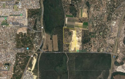
City of Rockingham Strategic Planning property summary
Zoned 'Special Rural' under the City of Rockingham's Town Planning Scheme No.2. The provisions of the 'Special Rural' zone can be found in Schedule 4 of the Town Planning Scheme/
o TPS2 Text Final Approval (3 February 2023) (rockingham.wa.gov.au)
The lot is identified as 'Urban Expansion' under the Perth and Peel @ 3.5 million, South metropolitan Peel Sub Regional Planning Framework.
o South Metropolitan Peel Sub-regional Planning Framework March 2018 (www.wa.gov.au)
The future of the site will be guided by the Karnup District Structure Plan, which the city has recently sought quotes from consultants for the project. Following an in-depth assessment, the city accepted the tender submitted from CDP Town Planning and Urban Design.
o Ordinary Council Minutes February 2023 (rockingham.wa.gov.au)
The Karnup District Structure Plan area ('the study area') is approximately 2000ha extending from Sixty Eight Road in the north to Paganoni Road in the south, and from Mandurah Road/Fletcher Road/Stakehill Road and Nairn Drive to the west, to Baldivis Road/Stakehill Road and Kwinana Freeway to the east (attached).
For updates on the project, please contact the City of Rockingham's Strategic Planning team or visit the City of Rockingham website.


