Goondiwindi QLD 4390
SearchBack to results
Sold on 4 May 2022

Goondiwindi QLD 4390

  • Rural / Farming
  • 3,657 ha
  • Sold

Goondiwindi Mixed Farming & Grazing Country

Expressions Of Interest Closing 5pm on the 9th March 2022

Area:
Approximately 3,657 Ha (9,036.45 Acres) Freehold in 13 Lots. Local government area of Goondiwindi Regional Shire Council. Rates approximately $19,218 per annum.

Location:
Rowanlea is approximately 35 km West of Goondiwindi with bitumen road access of the Gooray Road. Approx. 256 km West of Toowoomba and 386 km West of Brisbane.

Services:
Mail service from Goondiwindi, Mobile phone service. Primary & Secondary schools in Goondiwindi with school bus access at end of Gooray Road. Livestock selling centres at Dalby, Toowoomba, Roma and Goondiwindi. Grain depots at Toobeah, Bungunya, Lundavra & Goondiwindi.

Rainfall: 575mm (23 inch) annual average.

Country:
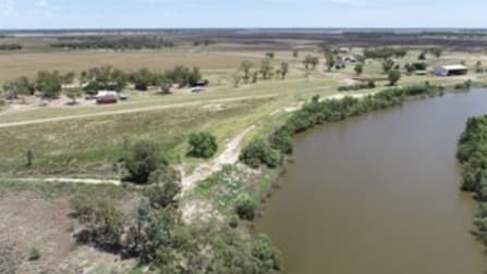
Rowanlea is located on flood plains of the Weir & McIntyre Rivers with a relatively flat topography. The country is a mix of heavy black flood plain soils, lighter loam box soils and areas of sand ridge. Original timbers consist of Coolabah, Belah & Myall in the heavy soils, Box, Wilga & Sandalwood in the lighter loam soils & Cypress, Box & Carbeen on the sand ridge areas. The property has a good mix of heavy farming & grazing soils with elevated areas of lighter soils & sand ridge. Grasses include Mitchell & Blue grass with native summer pastures & winter herbages in the heavier soils and areas of Buffel & Panic in the loam & sandy soil.

Cultivation:
An area of Approximately 1,756 Ha (4,339 Ac) is currently developed dry-land farming utilized for both grain & fodder cropping. Recent cropping history has been a winter cereal & pulse rotation with the opportunity to grow grain crops in any season. The cultivation country presents with a good cover of winter stubble and a good start to the moisture profile with above average rains & some flooding post 2021 winter harvest.

Water:
"Rowanlea" is well water via a combination of nine dams and lagoons for stock use. It is also part of the Callandoon Bore Scheme which is piped to storage tanks & troughs that provide secure water for livestock and spraying requirements. The lower lying areas benefit from Weir river flooding in major rain events with one main watercourse traversing the property from east to west. The homestead is serviced by bore, dam & rain water.

Fencing:
"Rowanlea" is very well fenced for both cattle & sheep. The boundary and internal fencing is a combination of plain & barb fences and netting & barb fences, all in good stock proof condition.

Infrastructure:
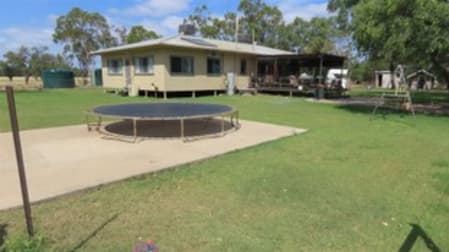
Comfortable 4 bedroom renovated home with open plan kitchen & living area.
Steel cattle yards with crush, calf cradle & loading ramp, water connected.
Relatively new raised board shearing shed / storage shed combined with steel sheep yards.
Enclosed work shop with concrete floor & power connected.
Silo Complex totalling 550 tonne.

Nutrien Harcourts Queensland
31 Amy Johnson Place
Eagle Farm, QLD 4009

Property Highlights

Date Sold4 May 2022
Floor AreaAsk Agent
Land Area3,657 ha
ParkingAsk Agent
Property ID2017571989
Category
Last updated  5 May 2022
Map for Goondiwindi QLD 4390
Nutrien Harcourts Queensland
31 Amy Johnson Place
Eagle Farm, QLD 4009

Property Highlights

Date Sold4 May 2022
Floor AreaAsk Agent
Land Area3,657 ha
ParkingAsk Agent
Property ID2017571989
Category
Last updated  5 May 2022

Listed by

Andrew Jakins
Andrew Jakins
Nutrien Harcourts Queensland
Call
0427 374 441

More about Goondiwindi QLD 4390

Goondiwindi QLD 4390 is categorized as Rural & Farming. It has a land area of 3,657 ha. The listing ID for this property is 2017571989.
More Rural / Farming properties for Sale in Goondiwindi QLD 4390

Sold
409 bangalow road,goondiwindi, QLD 4390
1,473.7 ha
Rural / Farming
Sold
goondiwindi, QLD 4390
2,003 ha
Rural / Farming
Sold
2312 south toobeah road,goondiwindi, QLD 4390
3,144.8 ha
Rural / Farming